Oceanic Volcanism in the Macaronesian Biome
Rising abruptly from the abyssal depths of the North Atlantic, the autonomous island regions of Madeira and the Azores represent two of the planet's most fascinating volcanic and botanical environments. While sharing a Portuguese heritage, their geomorphology and climates diverge significantly.
Madeira is a shield volcano with severe verticality, where 1,800-meter peaks drop precipitously into crashing surf. The Azores archipelago, located 1,500 kilometers west of the mainland along the triple junction of the North American, Eurasian, and African tectonic plates, comprises nine verdant volcanic islands defined by steaming fumaroles, calderas, and hot mineral springs.
Madeira: Engineering the Levadas and Laurisilva
Because the prevailing trade winds deposit massive rainfall onto Madeira’s northern slopes while the sunny southern agricultural coast suffers from water deficits, early settlers constructed an astonishing engineering feat: the Levadas. Over 3,000 kilometers of narrow stone and concrete aqueducts were carved by hand into sheer basalt cliffs to transport fresh water across the central cordillera.
Today, the narrow maintenance pathways alongside these channels form one of the world's most spectacular hiking networks:
- Levada das 25 Fontes: Originating on the Paul da Serra high plateau and descending through ancient moss-draped heath forests into an amphitheater of 25 natural springs trickling down weeping stone walls.
- Levada do Caldeirão Verde: Carved into sheer precipices in the heart of the UNESCO-protected Laurisilva forest, penetrating hand-hewn basalt tunnels before terminating at a 100-meter vertical waterfall.
- Pico do Arieiro to Pico Ruivo (PR1): A demanding ridgeline traverse connecting Madeira's third and highest summits above a blanket of Atlantic clouds.
Hiking Preparation Notice: Headlamps Required
Levada treks regularly traverse unlit tunnels carved through mountain ridges, some stretching several hundred meters with low ceilings and wet flooring. Always pack a reliable LED headlamp and waterproof shell, even on days starting with clear skies in Funchal.
The Azores: São Miguel and Mount Pico
In the Azores, volcanic energy remains tangibly close to the surface. On São Miguel, the largest island, the village of Furnas sits inside an active caldera where geysers steam and locals slow-cook Cozido das Furnas (a rich stew of meats and root vegetables) by burying sealed metal pots in volcanic earth heated by geothermal vents for six hours.
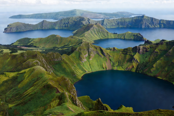
Nearby lies the majestic Sete Cidades, a massive twin lake resting inside a three-mile-wide caldera—one lake glowing emerald green, the other shimmering cobalt blue according to sunlight angles and botanical depths.
Further west in the Central Group, the island of Pico is dominated by Mount Pico (Montanha do Pico). Ascending 2,351 meters directly from the Atlantic waves, it is Portugal’s highest mountain. Around its base, the UNESCO-recognized Paisagem da Cultura da Vinha da Ilha do Pico displays an incredible grid of black basalt stone currais (walled enclosures) built to protect delicate Verdelho vines from Atlantic salt spray.